
Queen of Track Building
Posts: 1613
Joined: Sun Dec 08, 2013 11:47 am
Location: Atlanta, GA, USA
Cars: Chevy Cobalt
![]() Mon Oct 13, 2014 12:54 pm
Mon Oct 13, 2014 12:54 pm
Streets of Atlanta Gran Prix (WIP)
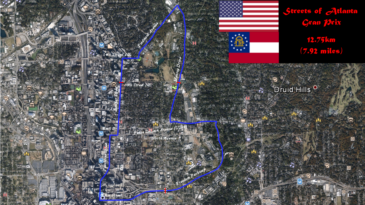
Streets Of Atlanta Gran Prix
Length: 12.75km (7.92 miles)
Laps: 25
Race: 319km (198 miles)
Date: Mid-April (due to the blooming Dogwoods and Azaleas which make Atlanta one of the most beautiful cities in the US!)
I invented this track for an original, fictitious, Real-World based track. I am using my local city and some historic streets around well-known landmarks. The route will be outlined below, so for those of you familiar with Downtown Atlanta, Georgia, you will have an idea of what the track will look like from the car. For those who do not, it isn't hard to find, as Atlanta, the business hub of the SouthEast, is quite a large city in the USA, and pictures of the landmarks mentioned below will be easy to find. Of course, the track will be centered around Piedmont Park, Atlanta's version of Central Park in New York City.
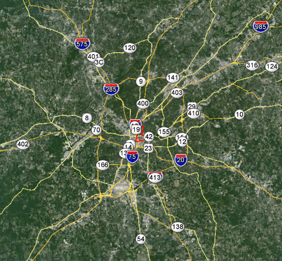
The 9th largest city in the United States of America is found in Atlanta, Georgia. While the City of Atlanta has just under 500k population, the Metropolitan Area, which covers over 8,300 square miles (21.6 square km), has a massive population of 5.5 million. A major transportation hub and home to the "World's Busiest Airport", Hartsfield-Jackson International, 3 major Interstate highways intersect in the busy Downtown District. Atlanta has the highest elevation of any major city which is located on the Eastern Seaboard of the United States of America. Elevations in the city range from 305-335m (1000-1100 ft). Specifically it is situated on Peachtree Ridge, along the Appalachian Plateau, with the Blue Ridge Mountains to the north.
First, let's have a good look at the track. On the West side is Downtown Atlanta. At the North end is Piedmont Park. The race begins on Freedom Parkway at Boulevard near Atlanta Medical Center.
For reference, here is an arial shot of the area with streets marked.
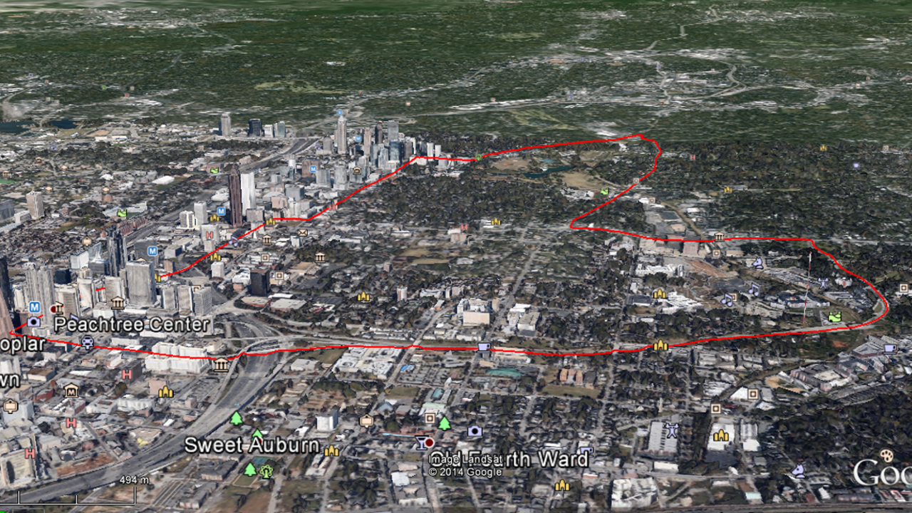
The Route:
And there you have it! Only 24 more laps to go to complete the Streets of Atlanta Gran Prix.
Track to come...
Length: 12.75km (7.92 miles)
Laps: 25
Race: 319km (198 miles)
Date: Mid-April (due to the blooming Dogwoods and Azaleas which make Atlanta one of the most beautiful cities in the US!)
I invented this track for an original, fictitious, Real-World based track. I am using my local city and some historic streets around well-known landmarks. The route will be outlined below, so for those of you familiar with Downtown Atlanta, Georgia, you will have an idea of what the track will look like from the car. For those who do not, it isn't hard to find, as Atlanta, the business hub of the SouthEast, is quite a large city in the USA, and pictures of the landmarks mentioned below will be easy to find. Of course, the track will be centered around Piedmont Park, Atlanta's version of Central Park in New York City.
The 9th largest city in the United States of America is found in Atlanta, Georgia. While the City of Atlanta has just under 500k population, the Metropolitan Area, which covers over 8,300 square miles (21.6 square km), has a massive population of 5.5 million. A major transportation hub and home to the "World's Busiest Airport", Hartsfield-Jackson International, 3 major Interstate highways intersect in the busy Downtown District. Atlanta has the highest elevation of any major city which is located on the Eastern Seaboard of the United States of America. Elevations in the city range from 305-335m (1000-1100 ft). Specifically it is situated on Peachtree Ridge, along the Appalachian Plateau, with the Blue Ridge Mountains to the north.
First, let's have a good look at the track. On the West side is Downtown Atlanta. At the North end is Piedmont Park. The race begins on Freedom Parkway at Boulevard near Atlanta Medical Center.
For reference, here is an arial shot of the area with streets marked.
The Route:
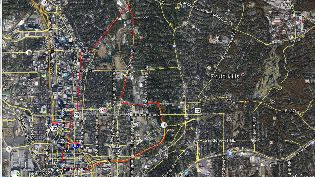
- Start is Boulevard and Freedom Parkway along the southern edge of the map heading East. Directly north of this location is Atlanta Medical Center, which will provide quick access in the need of medical attention during the event. Further along, the road turns to the North, where you will find the Jimmy Carter Presidential Library & Museum. It is highly recommended to visit this location while you are here to see the race! The road is sweeping left and right curves as it progresses North toward Ponce De Leon Avenue.
- There is a hard left at the intersection of Ponce De Leon Avenue taking the route West into Midtown past the historic City Hall East and on down to the intersection at Monroe Drive. This area is alive with restaurants and shopping for the off-beat aficionado.
- At Monroe Drive, the route takes a hard right speeding North through the Midtown and Virginia Highlands districts, and eventually along the East edge of Piedmont Park.
- There is a roundabout located at the intersection of Piedmont Avenue and Monroe Drive, which will have to be navigated with care as it is a 15 foot climb and decent down to the road below, which will give you a clear view of Smith's Old Bar and Ansley Mall, with a left turn onto Piedmont Avenue heading South. Piedmont Park is on the left now, with the Atlanta Botanical Gardens just before the next turn.
- 14th Street is the first short jog in the course, which carries the route to the 14th Street Playhouse at Juniper Street.
- A short 10 blocks down Juniper Street brings us back to Ponce De Leon Avenue again for another quick jog over to Peachtree Street.
- After a quick left onto Peachtree Street, behind you is the Atlanta High Museum and Arts Center Complex and ahead of you is the main corridor through Atlanta heading towards Downtown Atlanta. While there are many things to see along this part of the route, the road is quite treacherous with the hills and curves as it winds between the skyscrapers lining the corridor. Here you can find the historic Fox Theater, Bank of America Tower, Sun Trust Tower Plaza, Wells Fargo Tower, Westin Atlanta Hotel, and Hyatt Atlanta Hotel Tower, just to name a few. When Peachtree Center and Peachtree Tower appear on the left, you have arrived at Ellis Street.
- With a hard left at Ellis Street, the course enters its final leg. Speeding back across the Downtown Connector, it becomes Freedom Parkway again.
And there you have it! Only 24 more laps to go to complete the Streets of Atlanta Gran Prix.
Track to come...

Swanson Motorsports Engineering Atlanta, GA, USA
American performance has no compromise!
Company ID: 1969666
SME on Automation Hub!
List of 2014 F1 tracks available **19/19 complete** Not all credit goes to me
Request your favorite track here